Why can’t I see an outage pin at my address?
The map groups nearby outages together into “clusters” to reduce cluttering at higher zoom levels. As you zoom in on a cluster, an outage pin is then placed in the center of the addresses associated with the outage. Note: In large outages spanning many square miles, the outage pin could be miles away from your address.
How do I know which outage pin represents my outage?
Typically, the pin closest to your address.
How do I see the details about my outage?
You can find out details about your outage by clicking on the outage pin and viewing the outage detail pane.
What do the different color pins mean?
The color of pin represents the number of customers affected by the outage. Click on the map legend to see what the different colors represent.
How can I stay up to date on information about my outage?
Receive important information about your outage via email, text, and voice by enrolling in outage notifications in My Account.
I am not sure my outage is on the map? What should I do?
You can easily report an outage online by clicking on the “Report Outage” button.
Search
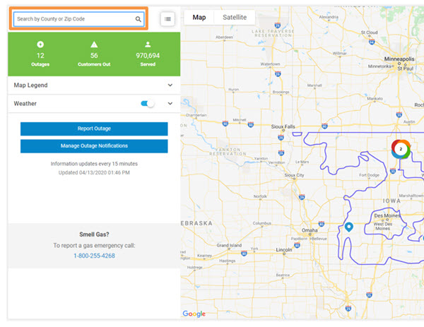
You can search by county or zip code to show a specific area on the map. To search, click or tap the magnifying glass at the top of the map, type the county or zip code into the search bar and press Enter or click Search.

Summary outage information
The section at the top of the tool panel shows summary information about electrical power outages as well as the time that information on the map was last updated.

Understanding the legend
To view the legend, click “Map Legend” to the left of the screen. The legend will appear below, which defines what each icon you may see means.


The map groups nearby outages together into “clusters” to reduce cluttering at higher zoom levels. You can also change the map background between map and satellite views.

Outage information panel
For information about an outage location, click or tap on the individual outage icon or outage cluster icon to open the info panel.

Weather
Click or tap on the "Weather" section of the map tool panel to open settings for turning on or off a static weather radar image (slider) or an animated weather radar image (loop).

Panning
To pan on the map, use the arrow keys on your keyboard or click or tap a point on the map and, without releasing, drag the map in any direction.
Zooming
To zoom in or out, click or tap the corresponding button (plus sign or minus sign) in the upper left corner of the map or rotate the wheel on your mouse or pinch in or out.
Map tools
You can view outage data by county or ZIP code. To change the map view, click or tap the list icon . This page also provides a list of customers affected by outages and customers served by county or by ZIP code.

This will replace the map and display each state Alliant Energy provides service in. Above where the states are listed, you can select what you would like to search – County or ZIP Code.

Once you have selected what you would like to search, select the state you would like to search in. This will expand a list of all counties and ZIP codes in the state that where Alliant Energy provides service. To view the desired area, click the view icon on the right side of the screen for that county or zip code. This will then display the map for that area.

You can also drill down your search by selecting the information you want to search (county or ZIP Code) and type in the appropriate information into the search window. Once you hit enter or select search, the information will display to the right for you to select the view icon.

Supported web browsers
Desktop
Google Chrome - latest version and previous version
Mozilla Firefox - latest version and previous version
Apple Safari - latest version and previous version on Mac OS X
Microsoft Internet Explorer 11
Internet Explorer's "compatibility view" is not supported
Microsoft Edge - latest version
Mobile devices
Google Android - Current version of Chrome on Android 4.4+
Apple iOS - Mobile Safari on the current and previous major versions of iOS
Outage map updates
If you are having difficulty using a feature described above, it may be necessary to clear your internet browser cache. To do this, hit Control-Shift-Delete. Leave the default settings as is and click “Delete.” Click the Refresh icon on your browser.
For additional information, see Google Maps Help.


